
This post was last updated on April 8th, 2014 at 05:19 pm
Trout Stream Flow Data In Jeopardy
If you are not familiar with the data available at the USGS website you have been missing out. The US Geological Survey provides free data for thousands of rivers throughout the United States. You can easily search for your state and choose the river you would like information for. It will give you very current data for the rate at which the river is flowing and you can easily compare it to previous years data. This is very valuable information for the trout fisherman. Unfortunately there have been major funding cuts throughout the program. As far as I can tell they are only partially cutting off the information. As you can see in the image a lot of these cuts have already taken place. There are a significant number of more shutdowns coming soon. October 1st will be the date that a lot of this information is cut off.
I don’t plan to talk about politics here as much as I would like to vent a little bit. Have a look at the image to the right. These are many of the USGS stations in jeopardy. Most of these stations are currently running because of local and state funding, otherwise 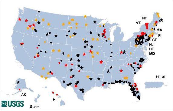 they would be already shut down. It appears that they will gradually pick away at these until they are gone.
![]() 35 Threatened Stations due to Sequestration, State/local agency has provided temporary funding through September 30, 2013
35 Threatened Stations due to Sequestration, State/local agency has provided temporary funding through September 30, 2013
![]() 15 Endangered Stations Due to Sequestration, Replacement funding has not been secured, Gage in process of being discontinued
15 Endangered Stations Due to Sequestration, Replacement funding has not been secured, Gage in process of being discontinued
![]() 39 Recently-discontinued Stations Due to Sequestration
39 Recently-discontinued Stations Due to Sequestration
89 Total Stations with Funding Issues Due to Sequestration
![]() 58 Threatened stations, Funding unlikely. Station maybe discontinued -or- a gage converted to stage-only
58 Threatened stations, Funding unlikely. Station maybe discontinued -or- a gage converted to stage-only
![]() 134 Endangered stations, Replacement funding has not been secured. Gage in process of being discontinued or converted to stage only
134 Endangered stations, Replacement funding has not been secured. Gage in process of being discontinued or converted to stage only
![]() 599 Recently-discontinued stations due to funding shortfall
599 Recently-discontinued stations due to funding shortfall
791 Total Stations with Funding Issues Due to Funding Shortfall
This is a terrible situation for the trout fisherman and all citizens. I can understand that a lot of people who pay taxes don’t really have much use for this data, but it is important to document water levels. Currently they are seeking funding for the closed stations and the areas that are at risk of closing, but so far things are not looking good.
My advice to you is
To take advantage of this wonderful data (if you don’t already) while we still have it available. It is really a serious predicament to get to a trout stream after a 2 hour drive, only to find out that a recent rain storm up stream has blown the river to smitherenes. You can access past river conditions and compare them to how they are now. This is important because current water temperatures can indicate to the fly fisherman what insects might be hatching. You can view recent pictures of many rivers listed and watch the trend line to determine whether the river is going up or down. It can be very important for trip planning as mentioned above. There are a ton of great resources here. If you have never been to the USGS water data site, go there and have a look. In an effort to help, I have also included individual links in all of the trout fishing areas in the main menu above (By State). Every trout fisherman in the United States should at least be a little disgruntled about this situation. You know the old saying “use it or lose it” in this case I guess it’s use it before you lose it, because its almost gone.